Have a Look at The Customozied Jumbo Jets of Billionaires !!!


Boeing 747 8 Interior

Boeing

Boeing 747-8 custom interior with 4786 sq. ft. of space.


The $65 million Gulfstream G650 may be the pinnacle of the private jet market, but it just doesn’t do the job for billionaires who prefer to fly with more than a dozen or so passengers.


For that, the uber wealthy turn to Airbus and Boeing, who are more than happy to customize their jets — even the widebodies that can carry hundreds of people — for private use.

Commercial jet manufacturers have been replacing the rows of economy seats in their aircraft with sofas and entertainment centers since the late 1990s. A recent influx of billionaires from Russia, the Middle East, and China has led to a new focus on this part of the business. Since opening the private jet branch in 1997, Airbus has sold over 170 aircraft. Boeing got started in 1996, and has delivered on 195 of 217 total orders received.

The main reason to go with an Airbus A380 or a Boeing 747 over a puny Gulfstream or Bombardier? According a “Billionaires Study” commissioned by Airbus, the wealthiest among us like to travel with family members and business associates. (This, apparently, is particularly true for Middle Eastern oil magnates.)

That’s not to say outfitting a jumbo jet for personal use is always a rational economic decision. For some, the bigger and more luxurious the plane, the better. That’s why Airbus and Boeing don’t just sell their planes, they offer a wide variety of customization options to give customers exactly what they want.

So how much does a personalized widebody plane cost? The manufacturers don’t exactly publish price lists, but we’ve seen figures between $80 million for a Boeing 737, $280 million for a Boeing 747-8, and up to $300 million for an A380.

Here’s a look at what’s available for billionaires ready to spend that big a pile of dough:


Boeing 787 Interior

Boeing

Boeing 787 interior ready for conversion.


ACJ319_Cabin_Tyrolean_Jet_Services_Airbus1

Airbus

Airbus A319 Corporate Jet.


Boeing Deer Jet

Deer Jet

Deer Jet owned Boeing with bedroom suite and shower.


Boeing Jet Interior

Boeing

Boeing interior with shower and king-sized bed.


Boeing 747 8 Sleeping Space

Boeing

Boeing 747-8 with sleeping space for 8.


ACJ318_Airbus_Tyrolean_Jet_Services_cabin1

Airbus

Airbus A318 Corporate Jet.


Airbus Phoenix_cabin_concept_Majhong_table_arrangement1

Airbus

Airbus Asian market interior with mahjong table.


Boeing Jet Shower

Boeing

Boeing interior shower.


ACJ319_Acropolis_Aviation_on_VVIP _angled_view_1

Airbus

Airbus A319 custom interior.

Read more: http://www.wired.com/2014/06/the-jumbo-jets-boeing-and-airbus-turn-into-posh-private-planes/#ixzz352DvEjqr

Source:::: Business Insider Select.au

Natarajan


” The OverView Effect” … Our World Looks More Organised !!!


Looking down from the heavens, these photos represent what satellites, hovering above the atmosphere, can see from high up, revealing a whole new world of shapes. The world can look more organized than it seems from down below, and these photos give a whole new meaning to the landscapes we’re used to seeing.

Don’t miss out on the video explaining this amazing phenomenon called: “The Overview Effect”.


Bourtange, Vlagtwedde, Netherlands
satellite photos
Barcelona, Spain
satellite photos
309th Aerospace Maintenance and Regeneration Group Tucson, Arizona, USA
satellite photos
Central Park, New York City, New York, USA
satellite photos
Great Wall of China, Northern China
satellite photos
Desert Shores Community, Las Vegas, Nevada, USA
satellite photos
New Bullards Bar Reservoir, Yuba County, California
satellite photos
Residential Development, Killeen, Texas, USA
satellite photos
Venice, Italy
satellite photos
Vineyards, Huelva, Spain
satellite photos
Plasticulture / Greenhouses, Almeria, Spain
satellite photos
Durrat Al Bahrain, Bahrain
satellite photos
Amazon Rainforest Deforestation, Para, Brazil
satellite photos


Port Newark-Elizabeth Marine Terminal, Newark, New Jersey, USA
satellite photos
Boca Raton, Florida, USA
satellite photos
Venture Out RV Resort, Mesa, Arizona, USA
satellite photos
Port of Los Angeles, Los Angeles, California, USA (containers)
satellite photos
Puente de Vallecas, Madrid, Spain
satellite photos
Agricultural Development, Addis Ababa, Ethiopia
satellite photos
Our Lady of Almudena Cemetery, Madrid, Spain
satellite photos
Palm Island / Hibiscus Island, Miami Beach, Florida, USA
satellite photos
Inman Yard, Atlanta, Georgia, USA
satellite photos
Spaghetti Junction (A-3 and M-50), Madrid, Spain
satellite photos
Agricultural Development, Loxahatchee, Florida, USA
satellite photos
Brøndby Haveby, Brønby Municipality, Denmark
satellite photos
Terraced Rice Paddies, Yuanyang County, Yunnan, China
satellite photos
Clearcutting in the El Dorado National Forest, Georgetown, California, USA
satellite photos
Edson, Kansas, USA
satellite photos
Central Pivot Irrigation Fields. Ha’il, Saudi Arabia
satellite photos

Source: Carlos. P  in ba-ba mail site

Natarajan

Watch the Earth’s Orbit Flash by in Seconds….First Ever Vine video From ISS !!!

  • Vine was created by Nasa astronaut Reid Wiseman over the weekend 
  • Timelapse condenses 92-minute orbit into the span of around six seconds
  • Sun never sets because ISS’ orbit is in alignment with the ‘terminator’ line
  • Terminator line marks barrier between light and dark on Earth’s surface
  • This happens up to four times a year but is most common around the time of the summer solstice

Astronauts on the International Space Station (ISS) can see as many as 16 sunrises and sunsets in a 24-hour period.

But on some occasions, the location of the station means the sun never sets at all, providing stunning views for the crew on board.

Now, Nasa astronaut Reid Wiseman has revealed this incredible sight from orbit, in the first ever Vine video to be sent from space.

The timelapse condenses a 92-minute orbit into the span of around six seconds showing the space station hurtling around the planet at  17,500 mph (27,600 km/h).

WHAT CAUSES A NEVER-SETTING SUN?

In certain orbits of the Earth, the sun never sets on the ISS because the space station is in alignment with the day/night terminator line.

This line marks the barrier between light and dark on the surface of the Earth.

In this scenario, something known as the ‘beta angle’ increases. This is the imaginary line between the sun and the path of the ISS around Earth.

When beta angle exceeds 69º, it is in constant sunlight. This happens two to four times a year and is most extreme near the summer solstice on June 21.

The timelapse condenses a 92-minute orbit into the span of around six seconds showing the space station hurtling around the planet at  17,500 mph (27,600 km/h).

 The sun never sets because the space station’s orbit comes into alignment with the day and night terminator line.

This marks the barrier between light and dark on the surface of the Earth.

In this scenario, something known as the ‘beta angle’ increases. This is the imaginary line between the sun and the path of the ISS around Earth.

Writing in the Weather Centre blog, Tony Rice explained that as the beta angle gets higher, the time the ISS is in sunlight also increases.

The sun never sets because the space station's orbit comes into alignment with the day and night terminator line. This marks the barrier between light and dark on the surface of the Earth

The sun never sets because the space station’s orbit comes into alignment with the day and night terminator line. This marks the barrier between light and dark on the surface of the Earth


During this period, the so-called ¿beta angle¿ increases. This is the imaginary line between the sun and the path of the ISS around Earth. As the beta angle gets higher, the time the ISS is in sunlight increases. When beta angle exceeds 69º, it is in constant sunlight

During this period, the so-called ‘beta angle’ increases. This is the imaginary line between the sun and the path of the ISS around Earth. As the beta angle gets higher, the time the ISS is in sunlight increases. When beta angle exceeds 69º, it is in constant sunlight

‘When beta angle exceeds 69º, it is in constant sunlight, and mission control keeps an even closer around-the-clock watch on power production and temperatures,’ he said.

‘This happens two to four times a year but is most extreme near the summer solstice coming on June 21.’

Previous space shuttles would enter something known as a ‘barbeque mode’ which would cause them to do slow barrel rolls to avoid overheating.

On the ISS, an Active Thermal Control System transfers heat through to large radiators extending under the station that can then be released into space.

Reid Wiseman from Baltimore (pictured) is currently serving as flight engineer aboard the International Space Station for Expedition 41.   Wiseman¿s space Vine has gained over 4,000 likes and nearly 2,000 retweets since it was posted on Saturday

Reid Wiseman from Baltimore (pictured) is currently serving as flight engineer aboard the International Space Station for Expedition 41.   Wiseman’s space Vine has gained over 4,000 likes and nearly 2,000 retweets since it was posted on Saturday

‘1st Vine from space! Single Earth orbit. Sun never sets flying parallel w/terminator line,’ Wiseman explained in the clip, which he shared over the weekend.

Vine is a mobile service that creates short looping videos which are six seconds or less. So far, Wiseman’s Vine has gained over 4,000 likes and nearly 2,000 retweets.

The 38-year-old from Baltimore is currently serving as flight engineer aboard the International Space Station for Expedition 41.

The last time Twitter saw a space ‘first’ was when astronaut Mike Massimino sent the first tweet from orbit in 2009.

'My parents were waving in Maryland at sunrise, so I took a picture of them,' Wiseman wrote with this shot

‘My parents were waving in Maryland at sunrise, so I took a picture of them,’ Wiseman wrote with this shot

Source:::: y ELLIE ZOLFAGHARIFARD  in Daily Mail Australia

Natarajan


Joke of the Day !!!

A pilot landed a plane with a rather bumpy landing. As part of his job he was required to stand by the terminal door and say goodbye to the passengers as they exited the airplane. He was afraid that someone might say something about his rather less than perfect landing, but everyone left without saying a word except for one passenger, an elderly lady, she slowly approached the pilot after most passengers had exited the plane and asked, “Did we land? Or were we shot down?”


Source::::joke a day .com

Natarajan

Image of the Day !!!


Jet zips past moon

“Aimed at the moon and started to focus when I saw the jet enter the frame … “

By GregDiesel Landscape Photography.  Visit his online gallery on Facebook.

Check out this cool image of an airplane passing in front of the moon. GregDiesel Landscape Photography captured it on May 31, 2014. He wrote:

Unless you live by an airport and try all day/night it’s a really tough shot to get! Story behind it was that I was just taking my ‘daily moon’ shot and my shutter froze. I took the lens off cleaned the sensors and snapped it back on. Aimed at the moon and started to focus when I saw the jet enter the frame and then, I mean, I needed split-second reaction to focus and get about 5 shots as it flew through in about 2 seconds start to finish. Got lucky with the timing.

Lucky for us! .

Click here to see Greg’s daily moon shots.

Source:::::Earth sky News site

Natarajan

A Plane in Space for 500 Days… How and Why ?… No Answer !!!

Featured Image for A plane has been in space for 500 days, and no one knows why

The X-37B is a kind of robotic space plane, built by the US. It’s been in Earth’s orbit for more than 500 days. And its real purpose is a complete mystery. Intrigued?

Here’s what we do know about X-37B

Constructed in California, the Boeing-built X-37B Orbital Space Vehicle was built for the US Air Force as a test vehicle; not intended to reach production. It is a quarter the size of the Endeavour Space Shuttle. It is equipped with heat-shield protection for re-entry to Earth’s atmosphere.

Currently the X-37B is orbiting at 28,044km/h, at a distance of around 350km in the sky. It can land, but no one will say when that will be.

It’s been in the sky before, after being launched on April 22, 2010, on a rocket. It then landed on December 3, 2010 – blowing a tire and suffering minor damage to its underbelly.

It took off again from Cape Canaveral on December 11, 2012 – now reaching 500 days in orbit.

The Air Force also launched a second model of X-37B on March 5, 2011. Described by the U.S. military as an “effort to test new space technologies”, it landed safely at Vandenberg Air Force Base on June 16, 2012, after 469 days in space. This third mission has now smashed this previous record.

X-37B’s actual functions are still heavily classified.

As you’d imagine, conspiracy theorists are having a field day, and here’s why:

Powered by a solar panel that unfurls once in orbit, X-37B can open with small, shuttle-like payload bay in its middle – think of a clamshell opening from underneath. There’s room for more than just a solar panel too. Exactly what items it carries, and why they need to be in space so long, has proved elusive for analysts, the space community, and the media.

To add further intrigue, the plane is classified as a secret project, yet maker Boeing has released pictures and more than two pages of details on the X-37B. That’s not how secrets are usually dealt with. By contrast, the secretLockheed SR-71 Blackbird was not declassified until decades after it had been flown in the Vietnam War.

The X-37 started life way back in 1999 when NASA asked Boeing’s Phantom Works division to develop an orbital test vehicle. This was a civilian project, and the X-37 was originally spec’d as an unmanned, robotic spacecraft that would rendezvous with satellites to refuel, repair them, or crash them back to Earth once their lifecycle was complete. But, in 2004, the project was transferred to DARPA and since then, it has been highly classified.

The amateur skywatching community that documents satellites say it’s orbiting between 43.5 degrees north latitude to 43.5 degrees south latitude. That’s a band around the middle of Earth that takes in much of the US, Middle East, and Asia, but is away from Russia, and Europe. Spotters suggest that at the altitude of 350km, it is ideal altitude for spying, but too low to refuel or fix other satellites.

It’s versatile, and has worked well enough that Boeing is contracted to create the next model, the X-37C. It will be at least 65% larger and have the ability to carry up to six astronauts, while operating unmanned.

The X-37B Orbital Test Vehicle

What we can guess

The two most popular theories suggest the vehicle is simply running an extended duration test – a marathon in space. The other theory is that the two previous missions prove the testing phase is complete, and it is now on an extended operation running a mission, or multiple missions.

The long endurance run theory has credit; proving that new, experimental critical components can work reliably for a long-duration in space, close to Earth.

The running-mission has credit too – with two previous missions complete, X-37B can now operate at length. And perhaps it is – observing, spying, experimenting, hosting space-weapons, or collecting data for the NSA. We just don’t know.

Both theories are plausible.

What it isn’t

Plenty of conspiracy theorist have posed the question of X-37B carrying a nuclear payload, to guarantee a ‘first strike’ opportunity (or to have a counter-option in place).

If you have any hope for humanity, that can’t be right. The US is a signatory to The Space Treaty, which is no joke. Space-based weapons of mass destruction are banned.

(One curious example of a space-based weapon that isn’t banned is a Kinetic strike, where objects whizzing around the Earth at great speed are intentionally sent to the ground, causing a meteorite-like impact and widespread damage. This type of attack is also known as ‘Rods from God’.)

An artist's conception of the X-37 Advanced Technology Demonstrator as it glides to a landing on earth.

source::::  Tristan Rayner in Exhale  …. http://www.techly.com.au

Natarajan

In Search of MH 370… Mapping of Underwater Terrain …


A new illustration of the seafloor, created by two of the world’s leading ocean floor mapping experts, details underwater terrain where the missing Malaysia Airlines flight might be located.


Image credit: AGU


Seafloor topography in the Malaysia Airlines flight MH370 search area. Dashed lines approximate the search zone for sonar pings emitted by the flight data recorder and cockpit voice recorder popularly called black boxes. The first sonar contact (black circle) was reportedly made by a Chinese vessel on the east flank of Batavia Plateau (B), where the shallowest point in the area (S) is at an estimated depth of 1637 meters. The next reported sonar contact (red circle) was made by an Australian vessel on the north flank of Zenith Plateau (Z). The inset in the top left shows the area’s location to the west of Australia. Image credit: Walter H.F. Smith and Karen M. Marks


Seafloor experts have created a new topography map that could shed additional light on what type of underwater vehicles might be used to find the missing airplane and where any debris from the crash might lie.

The seafloor topography map illustrates jagged plateaus, ridges and other underwater features of a large area underneath the Indian Ocean where search efforts have focused since contact with Malaysia Airlines flight MH370 was lost on March 8. The image was published today in Eos, the weekly newspaper of the Earth and space sciences, published by the American Geophysical Union.

The new illustration of a 2,000 kilometer by 1,400 kilometer (1,243 miles by 870 miles) area where the plane might be shows locations on the seafloor corresponding to where acoustic signals from the airplane’s black boxes were reportedly detected at the surface by two vessels in the area. It also shows the two plateaus near where these “pings” were heard.

It points out the deepest point in the area: 7,883 meters (about five miles) underneath the sea in the Wallaby-Zenith Fracture Zone – about as deep as 20 Empire State buildings stacked top to bottom. Undersea mountains and plateaus rise nearly 5,000 meters (about three miles) above the deep seafloor, according to the map.

The illustration, designated as Figure 1 of the Eos article, was created by Walter H.F. Smith and Karen M. Marks, both of the National Oceanic and Atmospheric Administration’s Laboratory for Satellite Altimetry in College Park, Maryland, and the former and current chairs, respectively, of the Technical Sub-Committee on Ocean Mapping of the General Bathymetric Chart of the Oceans, or GEBCO. GEBCO is an international organization that aims to provide the most authoritative publicly available maps of the depths and shapes of the terrain underneath the world’s oceans.

Satellite altimetry has made it possible to depict the topography of vast regions of the seafloor that would otherwise have remained unmapped, Smith said. To illustrate the topography of the search area, Smith and Marks used publicly available data from GEBCO and other bathymetric models and data banks, along with information culled from news reports.

Smith said the terrain and depths shown in the map could help searchers choose the appropriate underwater robotic vehicles they might use to look for the missing plane. Knowing the roughness and shape of the ocean floor could also help inform models predicting where floating debris from the airplane might turn up.

Smith cautions that the new illustration is not a roadmap to find the missing airplane. Nor does the map define the official search area for the aircraft, he added.

“It is not ‘x marks the spot’,” Smith said of their map. “We are painting with a very, very broad brush.”

Search efforts for the missing airplane have focused on an area of the southern Indian Ocean west of Australia where officials suspect that the plane crashed after it veered off course. After an initial air and underwater search failed to find any trace of the airplane, authorities announced this month that they will expand the search area and also map the seabed in the area.

Smith pointed out that the search for the missing plane is made more difficult because so little is understood about the seafloor in this part of the Indian Ocean. In the southeast Indian Ocean, only 5 percent of the ocean bottom has been measured by ships with echo soundings. Knowledge of the rest of the area comes from satellite altimetry, which provides relatively low-resolution mapping compared to ship-borne methods.

“It is a very complex part of the world that is very poorly known,” Smith said.

A lack of good data about Earth’s seafloors not only hinders search efforts, it also makes it harder for scientists to accurately model the world’s environment and climate, Smith noted. Today, our knowledge of our planet’s undersea topography is “vastly poorer than our knowledge of the topographies of Earth’s Moon, Mars and Venus,” Smith and Marks write in Eos. This is because these other planetary bodies have no oceans, making their surfaces relatively easy to sense from space.

Smith said he hoped that “the data collected during the search for MH370 will be contributed to public data banks and will be a start of greater efforts to map Earth’s ocean floor.”

Via AGU

source:::: Earth SKY News site

Natarajan

Image of the Day…


Kelvin Helmholtz clouds

It looks like someone painted the sky with breaking ocean waves. They are called Kelvin Helmholzt clouds, aka as billow clouds or shear-gravity clouds.

View larger. |  Photo credit: Paul Chartier

Here’s a special kind of cloud known to scientists as a Kelvin Helmholtz cloud. They look like breaking ocean waves, with the rolling eddies seen at the top of the cloud layers usually evenly spaced and easily identifiable. Kelvin Helmholtz clouds are named for Lord Kelvin and Hermann von Helmholtz, who studied the physics of the instability that leads to this type of cloud formation.

How Kelvin Helmholtz clouds form. A Kelvin Helmholtz instability forms where there’s a velocity difference across the interface between two fluids: for example, wind blowing over water. You’ll often see the characteristic wave structure in this type of cloud when two different layers of air in our atmosphere are moving at different speeds. The upper layers of air are moving at higher speeds and will often scoop the top of the cloud layer into these wave-like rolling structures.

The clouds often form on windy days, when there’s a difference in densities of the air, for exmaple, during a temperature inversion.

These clouds are often good indicators of atmospheric instability and the presence of turbulence for aircraft.


source::::Earth sky news site

Natarajan


A Man Hijacks a Plane…Collects His Ransom Money and Jumps out Of Plane …!!!


This Day In History: November 24, 1971

An unidentified man referred to as D.B. Cooper hijacked a Boeing 727 airplane between Portland, Oregon and Seattle, Washington.   Cooper bought a one-way ticket on a Northwest Orient Airlines, Flight 305 to Seattle, Washington leaving Portland, Oregon at 2:50 p.m.  He brought with him aboard the plane a black suit-case supposedly containing a bomb.

During the 30 minute flight, Cooper handed a ransom note to the nearby flight attendant telling her he had a bomb and was going to use it if necessary.   He demanded $200,000 in unmarked $20 dollar bills, along with two front parachutes and two back parachutes.  His demands were delivered to the pilot William Scott, who then delivered them to the air traffic control center at the Seattle-Tacoma Airport. Cooper’s flight landed at the SEA-TAC Airport at 5:45 p.m.   After his money and parachutes were delivered, the passengers were released along with two of the flight attendants.  The hijacker then delivered his flight plan to the cockpit crew.   The plane was to take a course heading southeast to Mexico City and was to maintain an altitude of 10,000 feet.  The crew was ordered by Cooper to remain in the cockpit for the duration of the flight.

At 7:40 p.m., the aircraft took off heading south.  At approximately 8:00 p.m., the instruments on the plane indicated that the door had been opened and the stairs lowered.  Outside at 10,000 feet the temperature was around 10 degrees below zero, the weather was stormy, and the wind speed would have been around 200 mph. Around 10:15 p.m., the aircraft landed in Reno with FBI Agents, state troopers, sheriff’s deputies, and the Reno police surrounded the aircraft.   After a quick search, it was confirmed that Cooper was no longer on the airplane and his approximant departure happened between 8:00 p.m. and 8:13 p.m. Even with a thorough search and an exhaustive FBI investigation, the hijacker has never been located nor positively identified.  Originally, they had tried to tail the plane, but chose military F-106 fighter jets to do it with, which could not fly as slow as the airline plane was required to fly by Cooper.

It is believed that he probably didn’t survive the jump.  First, the F.B.I. had trouble locating parachutes for Cooper in the time they had allotted.  Because of this, out of the four chutes they gave him, they accidentally gave him one non-functional practice parachute and one parachute that was quite old.  They had not intended to give him bad parachutes at the time, because they thought there was a chance he’d be taking some of the crew with him.  He didn’t, but did pick the old primary parachute and the secondary non-functional, practice chute.  Further, Cooper had no jacket or rain protective gear and jumped on a cold stormy, pitch-black night into hilly terrain filled with trees.  Finally, no spent money has ever been recovered with the serial numbers matching those given to Cooper.  There has been $5,800 recovered though, which was found near the Columbia River about 40 miles from the predicted landing site, still bundled.   However, this isn’t seen as conclusive evidence that he didn’t survive because it could have just as easily been blown out of the bag during the jump or accidentally left there, if Cooper took a boat downstream.  In addition to that, there were ten bills missing from the bundles, which would likely have had to be manually taken out of the tightly bound bundles.  Further, the parachutes were very brightly covered and should have been easy to spot had he not survived.  So the mystery continues on whether he survived and who exactly he was in the first place.  Even recent DNA samples from evidence left in the plane have failed to turn up any leads.

source::::Today i foundout.com

natarajan

Why Don’t Commercial Airplanes Have Parachutes for Passengers? ….


parachuteSeatbelts and airbags in cars save passengers lives. Parachutes save people who, for a variety of reasons, exit a plane in mid-flight. So why aren’t parachutes provided to passengers on commercial airline flights, in case of emergencies?

Because they almost certainly would not save anyone’s life.

Parachuting Basics

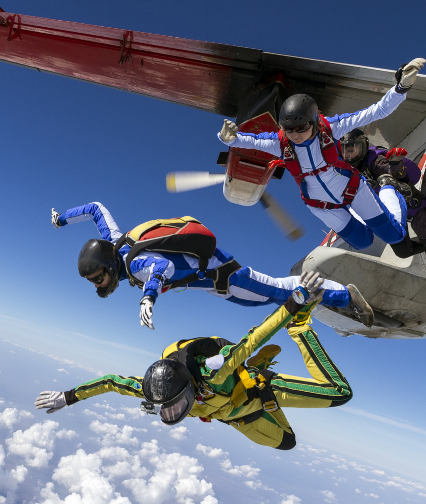
When your average daredevil skydives for fun, the plane is typically travelling at between 80 and 110 mph when the skydiver jumps.Tandem and accelerated free fall (AFF) jumps occur between 10,000 and 13,000 feet, while static jumps can be as low as 3,500 feet.

Student divers choosing the easiest, tandem jump, where the newbie is physically and securely attached to an experienced instructor, are still required to undergo “a half hour of basic ground instruction.”

Braver neophytes who wish to fly untethered will have to endure:

Four to five hours of intense ground instruction, including learning body flight maneuvers and hand signals that instructors use to coach the student as they fly alongside.

For an AFF jump, although not harnessed together, freshman flyers are accompanied by two instructors who “hold onto the student’s harness until” it’s deployed.

Those who choose a static line jump also have to take four + hours of training prior to the jump, although the parachute is deployed as the rookie flyer leaves the aircraft.

When skydivers leave a plane, they do it alone or in small groups. When successive groups will be jumping, they try to keep separated by anywhere between 500 and 1500 feet; this is often accomplished by waiting until the preceding group is “back under the tail to 45 degrees behind the airplane” or several seconds in between groups.

Experienced skydivers can make even riskier jumps, although when descents begin at higher than 15,000 feet, “the risk of hypoxia and being significantly affected by altitude” increases dramatically and divers are less able “to make effective safe decisions at critical times.” Therefore, divers who jump from 15,000 feet or higher carry supplemental oxygen.

Further, each parachute weighs around 40 pounds and the equipment is expensive. To be fully outfitted with “rig, main, reserve, ADD, altimeter, jumpsuit, helmet [and] goggles” can run between $5,900 and $9,000.

Commercial Airplane Basics

Perhaps the most popular commercial jetliner is the Boeing 737 family. Its 737-800 can carry nearly 200 people (including the crew).

Although speeds can vary slightly, the 737-800 travels at approximately 600 mph when at its cruising altitude of 35,000 feet. Cruising altitudes are assigned by air traffic controllers and are usually up to 39,000 feet, except for longer flights that may fly higher.

Individual Parachutes Won’t Improve Passenger Safety

Doing the math . . .

Passenger Training

Since four hours of training just to board a plane is unrealistic, passengers would have to read and execute detailed skydiving instructions including how to properly strap the chute on in order to benefit from the parachute. Not everyone is good at following detailed, technical instructions even when time and stress aren’t a factor.  In a situation where the plane is going down and one has only a moment to get the parachute properly strapped on (likely while keeping an oxygen mask firmly attached and perhaps also needing to keep the seat belt on to keep from being thrown about in the cabin), it’s unlikely most would be able to even get this far.

Every Man for Himself

Unless passengers wanted to fly suited up and tethered for a static jump, parachuting from a commercial airplane will be an AFF jump; however, unlike the conditions that students get – training and trained instructors to assist, commercial passengers will just have to learn as they go.

In addition, they will have to keep calm and proceed in an orderly fashion, which will require most to patiently wait their turn to exit. This is not likely to happen.

Parachuting Equipment is Bulky

Adding just parachutes (not counting helmets, altimeters, etc.) for each passenger would add another 8,000 pounds or so to the flight’s weight. In addition, that equipment would take up space, that is already at a premium.

Parachuting Only Makes Sense if Something Happens in Mid-Flight

The only feasible time for people to jump from the plane is while it’s cruising. However, most fatal airline accidents occur on airplanes during takeoff and landing.

Consider that between 2003 and 2012, only 9% of all fatal accidents on commercial flights, seven total, occurred while the plane was cruising; moreover, at least one of those accidents happened as a result of wind shear or thunderstorm. This is a situation where parachuting is extremely dangerous even if you’re an expert.

So even if parachuting were feasible from a jetliner, the conditions in which parachutes could theoretically save lives are almost never apparent in fatal commercial accidents. But even if they were, it still wouldn’t be a good idea.

Jetliners Cruise Very High and Very Fast

At 35,000 feet (three times higher than a typical jump) every passenger would need high altitude equipment (HALO) that includes an oxygen tank, mask and regulator, flight suit, ballistic helmet and altimeter just to manage the thin air. Or they could just pass out from hypoxia and wake up later, hopefully when the parachute automatically deployed at under 15,000-20,000 feet.

Of course, none of this would matter since the plane is moving so fast (600 mph), and it is so large, that many passengers would almost certainly smash into it and suffer debilitating if not fatal injuries.

Whole Plane Parachutes May Save Lives

There is hope, however. Over the past few years, many small planes have been equipped with whole-plane parachutes that slow the craft’s descent. As of late 2013, the largest planes equipped with these safety devices carry five people, but plans are in the works for putting them on larger crafts. As one manufacturer said, “There is no doubt that big commercial airlines of the future will be equipped with some kind of parachute recovery system.”

source:::: Today i foundout.com

natarajan